


Eastwood Elem School, Morgan County, Alabama
About
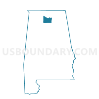
Outline

Summary
| Unique Area Identifier | 522758 |
| Name | Eastwood Elem School |
| County | Morgan County |
| State | Alabama |
| Area (square miles) | 3.70 |
| Land Area (square miles) | 2.52 |
| Water Area (square miles) | 1.18 |
| % of Land Area | 68.07 |
| % of Water Area | 31.93 |
| Latitude of the Internal Point | 34.57905830 |
| Longtitude of the Internal Point | -86.94188250 |
Maps


Graphs
Select a template below for downloading or customizing gragh for Eastwood Elem School, Morgan County, Alabama


Neighbors
Neighoring Voting District (by Name) Neighboring Voting District on the Map
- American Legion Building, Morgan County, AL
- Belmore Baptist Church, Limestone County, AL
- Decatur Fire & Rescue Station, Morgan County, AL
- Morgan Co Dept Of Human Resources, Morgan County, AL
- Priceville Fire Station, Morgan County, AL
- Somerville Rd Elem School, Morgan County, AL
- Walter Jackson Elem School, Morgan County, AL
Top 10 Neighboring County Subdivision (by Population) Neighboring County Subdivision on the Map
- Decatur CCD, Morgan County, AL (61,269)
- Hartselle CCD, Morgan County, AL (20,946)
- Somerville CCD, Morgan County, AL (10,369)
- Mooresville CCD, Limestone County, AL (9,438)
Top 10 Neighboring Place (by Population) Neighboring Place on the Map
Top 10 Neighboring Unified School District (by Population) Neighboring Unified School District on the Map
- Limestone County School District, AL (57,348)
- Decatur City School District, AL (55,683)
- Morgan County School District, AL (50,012)
Top 10 Neighboring State Legislative District Lower Chamber (by Population) Neighboring State Legislative District Lower Chamber on the Map
Top 10 Neighboring State Legislative District Upper Chamber (by Population) Neighboring State Legislative District Upper Chamber on the Map
Top 10 Neighboring 111th Congressional District (by Population) Neighboring 111th Congressional District on the Map
Top 10 Neighboring Census Tract (by Population) Neighboring Census Tract on the Map
- Census Tract 212, Limestone County, AL (9,438)
- Census Tract 53.01, Morgan County, AL (7,940)
- Census Tract 54.04, Morgan County, AL (5,161)
- Census Tract 51.09, Morgan County, AL (4,577)
- Census Tract 1, Morgan County, AL (4,435)
- Census Tract 2, Morgan County, AL (3,623)
- Census Tract 3, Morgan County, AL (2,748)